Tony Smith's Home Page
NILE LAKES
At 11,600 years ago,
about when the Vela X supernova was seen in Earth,
a very sudden (50 years or so) warming event
ended the Ice Age and marked the start of the HOLOCENE AGE
of warm climate and glacial retreat.
As the glaciers melted, lakes filled the Nile River Valley.
From 11,600 years ago to 9,000 years ago, the lakes filled up.
From 9,000 years ago to 6,000 years ago, the lakes were full,
and the Nile River Valley was rainy,
with over 30 cm per year net precipitation over evaporation loss.
From 6,000 years ago to 4,500 years ago, the lakes dried out,
leaving few with high levels, some medium, but most low,
and the net precipitation declined.
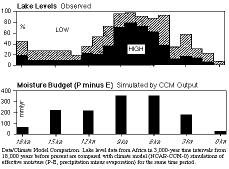 From 4,500 years ago to now, the Nile River Valley had few lakes
and a dry climate.
As Schwaller de Lubicz, West, Schoch, Bauval, and Hancock have noted,
the Sphinx shows clear geological signs of rain-water weathering,
so the Sphinx must have been built
before the end of the rainy weather in the Nile River Valley.
If the Sphinx and the Giza Pyramids were all built together,
they were most likely built from 9,000 to 6,000 years ago.
The 9,000-6,000 year old Sphinx-Giza Civilization
had 2,600 years to develop to a high level
after the sudden warming event ended the Ice Age 11,600 years ago,
and
3,000 years of continual benevolent Nile River Valley climate
until the rains stopped and the lakes dried up 6,000 years ago.
In that 3,000 years,
they could have built things such as the Sphinx and the Giza Pyramids,
and developed hieroglyphics and mathematics.
The period from 6,000 to 4,500 years ago
must have put great stress on the Sphinx-Giza Civilization,
as it was losing its lakes and rains.
To see what happened, look at the geography of the Nile River Valley.
In the video The Mystery of the Sphinx (The Sphinx Project, 1993),
paleoclimatologist John Kutzbach shows
the general region of African lakes 9,000 years ago as:
From 4,500 years ago to now, the Nile River Valley had few lakes
and a dry climate.
As Schwaller de Lubicz, West, Schoch, Bauval, and Hancock have noted,
the Sphinx shows clear geological signs of rain-water weathering,
so the Sphinx must have been built
before the end of the rainy weather in the Nile River Valley.
If the Sphinx and the Giza Pyramids were all built together,
they were most likely built from 9,000 to 6,000 years ago.
The 9,000-6,000 year old Sphinx-Giza Civilization
had 2,600 years to develop to a high level
after the sudden warming event ended the Ice Age 11,600 years ago,
and
3,000 years of continual benevolent Nile River Valley climate
until the rains stopped and the lakes dried up 6,000 years ago.
In that 3,000 years,
they could have built things such as the Sphinx and the Giza Pyramids,
and developed hieroglyphics and mathematics.
The period from 6,000 to 4,500 years ago
must have put great stress on the Sphinx-Giza Civilization,
as it was losing its lakes and rains.
To see what happened, look at the geography of the Nile River Valley.
In the video The Mystery of the Sphinx (The Sphinx Project, 1993),
paleoclimatologist John Kutzbach shows
the general region of African lakes 9,000 years ago as:
 A more detailed view of African lake levels 6,000 years ago,
as compared with now, is:
A more detailed view of African lake levels 6,000 years ago,
as compared with now, is:
 To see specifically how the Nile River Valley was affected,
look at its topography (compiled from MacGlobe):
To see specifically how the Nile River Valley was affected,
look at its topography (compiled from MacGlobe):
 The map shows elevation of the region
from the headwaters area of the Nile River
around the Abyssinian Highlands
to the mouth of the Nile River
at the Mediterranean Sea in the North.
The Red Sea is on the East.
The lowest levels are the dark green,
under 656 feet, roughly the elevation
of the top of the two large Giza Pyramids.
The lowest lands are mostly North of
the Safsaf Oasis, marked x labelled SafSaf.
It is about 200 miles West
of the current bed of the Nile River.
Safsaf was mapped by synthetic aperture radar
on 9 April 1994 from the Space Shuttle Endeavour:
The map shows elevation of the region
from the headwaters area of the Nile River
around the Abyssinian Highlands
to the mouth of the Nile River
at the Mediterranean Sea in the North.
The Red Sea is on the East.
The lowest levels are the dark green,
under 656 feet, roughly the elevation
of the top of the two large Giza Pyramids.
The lowest lands are mostly North of
the Safsaf Oasis, marked x labelled SafSaf.
It is about 200 miles West
of the current bed of the Nile River.
Safsaf was mapped by synthetic aperture radar
on 9 April 1994 from the Space Shuttle Endeavour:
 To parapharase part of a report on the
JPL Imaging Radar Home Page of Bruce Chapman:
The image is centered at Safsaf, 22 degrees North latitude,
29 degrees East longitude.
It shows detailed structures of bedrock;
the dark blue sinuous lines are braided channels
that occupy part of an old broad river valley.
On the ground and in optical photographs,
this big valley and the channels in it are invisible
because they are entirely covered by windblown sand.
The Nile flows north about 200 miles to the East.
The small channels probably formed
during relatively wet climatic periods.
The image clearly shows that in wetter times,
the valley would have supported game animals and vegetation.
Today, as a result of climate change,
the area is uninhabited
and lacks water except for a few scattered oases.
You can see that during rainy times, such as the time
of the Sphinx-Giza Civilization 9,000 to 6,000 years ago,
a broad region (roughly light green + dark green)
was probably covered by a network of lakes and rivers.
Most of the real-estate development
of the Sphinx-Giza Civilization would probably
have been along the banks of those old lakes and rivers,
now buried by sand and only visible by radar.
WHERE WOULD THE CENTER OF THE SPHINX-GIZA CIVILIZATION
HAVE BEEN LOCATED?
My opinion is that it would not have been located
in the lowlands North of Safsaf,
because too much of the region would have been
in the flood plain to be developed.
A prominent exception would have been the Giza Plateau,
the site of the Sphinx and the Giza Pyramids.
The part of the Nile River Valley
from its headwaters near the Equator
running North to Safsaf is shown in this
map (compiled from MacGlobe):
To parapharase part of a report on the
JPL Imaging Radar Home Page of Bruce Chapman:
The image is centered at Safsaf, 22 degrees North latitude,
29 degrees East longitude.
It shows detailed structures of bedrock;
the dark blue sinuous lines are braided channels
that occupy part of an old broad river valley.
On the ground and in optical photographs,
this big valley and the channels in it are invisible
because they are entirely covered by windblown sand.
The Nile flows north about 200 miles to the East.
The small channels probably formed
during relatively wet climatic periods.
The image clearly shows that in wetter times,
the valley would have supported game animals and vegetation.
Today, as a result of climate change,
the area is uninhabited
and lacks water except for a few scattered oases.
You can see that during rainy times, such as the time
of the Sphinx-Giza Civilization 9,000 to 6,000 years ago,
a broad region (roughly light green + dark green)
was probably covered by a network of lakes and rivers.
Most of the real-estate development
of the Sphinx-Giza Civilization would probably
have been along the banks of those old lakes and rivers,
now buried by sand and only visible by radar.
WHERE WOULD THE CENTER OF THE SPHINX-GIZA CIVILIZATION
HAVE BEEN LOCATED?
My opinion is that it would not have been located
in the lowlands North of Safsaf,
because too much of the region would have been
in the flood plain to be developed.
A prominent exception would have been the Giza Plateau,
the site of the Sphinx and the Giza Pyramids.
The part of the Nile River Valley
from its headwaters near the Equator
running North to Safsaf is shown in this
map (compiled from MacGlobe):
 You can see that much of the White Nile
part of the region is even now swampy,
so I don't think that the Sphinx-Giza Center
would have been there.
However, the Blue Nile,
and other Nile tributaries to its North and East,
drained from the Abyssinian Highlands.
The Blue Nile Basin may have been
a relatively stable system of land, lakes, and rivers
that could have been the basis for a
high civilization centered in
the Abyssinian Highlands.
Another reason why I think that
the Sphinx-Giza Center may have been
in the Abyssinian Highlands
is that it had the best climate:
a high-altitude tropical climate.
(To see how nice such a climate is,
and why the leaders of the Sphinx-Giza Civilization
would have wanted to live there, go to Asmara today.)
Still another reason is that
Egyptians called all of the lands
south and southeast of Egypt:
Ta-netjer, "God's Land".
Further (see The Message of the Sphinx,
by Hancock and Bauval), The Book of Two Ways,
written on Egyptian coffins about 4,000 years ago,
refers to:
the Highland of Aker, which is the Dwelling Place of Osiris.
According to Hancock and Bauval, the word Aker
is similar to the word Akeru meaning ancestors of Re,
and to the word Akhu meaning
Venerable, Transfigured Being, Shining Being, or Astral Spirit.
Since the Great Rift Valley of East Africa is nearby,
people living there could directly observe a lot of
natural geological and chemical activity.
You can see that much of the White Nile
part of the region is even now swampy,
so I don't think that the Sphinx-Giza Center
would have been there.
However, the Blue Nile,
and other Nile tributaries to its North and East,
drained from the Abyssinian Highlands.
The Blue Nile Basin may have been
a relatively stable system of land, lakes, and rivers
that could have been the basis for a
high civilization centered in
the Abyssinian Highlands.
Another reason why I think that
the Sphinx-Giza Center may have been
in the Abyssinian Highlands
is that it had the best climate:
a high-altitude tropical climate.
(To see how nice such a climate is,
and why the leaders of the Sphinx-Giza Civilization
would have wanted to live there, go to Asmara today.)
Still another reason is that
Egyptians called all of the lands
south and southeast of Egypt:
Ta-netjer, "God's Land".
Further (see The Message of the Sphinx,
by Hancock and Bauval), The Book of Two Ways,
written on Egyptian coffins about 4,000 years ago,
refers to:
the Highland of Aker, which is the Dwelling Place of Osiris.
According to Hancock and Bauval, the word Aker
is similar to the word Akeru meaning ancestors of Re,
and to the word Akhu meaning
Venerable, Transfigured Being, Shining Being, or Astral Spirit.
Since the Great Rift Valley of East Africa is nearby,
people living there could directly observe a lot of
natural geological and chemical activity.
 As they could have learned from what they saw,
the Abyssinian Highland Civilization could have
been technologically advanced.
What do we now know about the Abyssinian Highlanders?
Their history is written in the Kbre Nege'st.
It is roughly consistent with the Jewish Old Testament.
There are some spectacular structures,
such as a 3-story church carved out of a solid rock:
As they could have learned from what they saw,
the Abyssinian Highland Civilization could have
been technologically advanced.
What do we now know about the Abyssinian Highlanders?
Their history is written in the Kbre Nege'st.
It is roughly consistent with the Jewish Old Testament.
There are some spectacular structures,
such as a 3-story church carved out of a solid rock:
 However, if the Abyssinian Highland Civilization
is the Sphinx-Giza Civilization,
it is fair to ask:
WHERE ARE THE INTERMEDIATE ARTIFACTS
BETWEEN THEM AND THE LOWER NILE TEMPLES AND STRUCTURES?
To answer this,
consider the period from 6,000 to 4,500 years ago.
The Blue Nile Basin was losing its lakes
and rainfall, so that it could no longer support
the Abyssinian Highlanders in the manner to
which they had become accustomed.
The entire region south of Safsaf dried up.
It was transformed from the most productive part
of the Sphinx-Giza Civilization to an arid desert.
From 4,500 years ago to the present,
the only productive area has been the narrow
lowland Nile River Valley, North of Safsaf.
Safsaf itself, being 200 miles West of the Nile River,
is too far away to be anything but a desert oasis.
The 1,500 year transition from
the 9,000 to 6,000 year old Sphinx-Giza Civilization,
with a large productive area including the Blue Nile Basin,
to
a much smaller narrow lowland Nile River Valley
productive area of the past 4,500 years
must have been traumatic.
After settling into a lowland Nile Valley Civiliation
4,500 years ago, the people there could have
used the hieroglyphics and mathematics inherited
from the earlier Sphinx-Giza Civilization,
and
they could have built some temples and structures.
Most of the Sphinx-Giza temples and structures would
have been far from the lowland Nile Valley,
as they would have been in places such as
borders of the old lakes and rivers South of Safsaf,
that had become deserts or distant highlands.
The outstanding exception would be
the Sphinx and the Giza Pyramids.
It would have been an example for
the lowland Nile Valley Civilization to try to reproduce.
However, the lowland Nile Valley Civilization
of the past 4,500 years would have had much less
resources than the Sphinx-Giza Civilization.
The Nile Valley lowlanders tried to copy
the 52-degrees slope of the Giza Pyramids.
First, they built step pyramids, with some success.
Then they tried to make the Meidum Pyramid into
a smooth 52-degree pyramid all the way to the top,
but it collapsed.
Then they started the Bent Pyramid at 52 degrees,
but changed the top part of the Bent Pyramid to 43-degrees
in order to avoid another collapse.
After that, they built the 43-degrees Red Pyramid,
and then they just gave up on pyramids,
the later ones being worse and worse.
Since the Giza Plateau was an impressive place,
the Nile Valley lowlanders modified and added to
the Sphinx-Giza Civilization structures,
producing a site with a mixture of things,
one effect of which is to confuse egyptologists,
some of whom attribute the Sphinx and
the Second Pyramid to the Nile Valley lowlander, Khafre.
However, if the Abyssinian Highland Civilization
is the Sphinx-Giza Civilization,
it is fair to ask:
WHERE ARE THE INTERMEDIATE ARTIFACTS
BETWEEN THEM AND THE LOWER NILE TEMPLES AND STRUCTURES?
To answer this,
consider the period from 6,000 to 4,500 years ago.
The Blue Nile Basin was losing its lakes
and rainfall, so that it could no longer support
the Abyssinian Highlanders in the manner to
which they had become accustomed.
The entire region south of Safsaf dried up.
It was transformed from the most productive part
of the Sphinx-Giza Civilization to an arid desert.
From 4,500 years ago to the present,
the only productive area has been the narrow
lowland Nile River Valley, North of Safsaf.
Safsaf itself, being 200 miles West of the Nile River,
is too far away to be anything but a desert oasis.
The 1,500 year transition from
the 9,000 to 6,000 year old Sphinx-Giza Civilization,
with a large productive area including the Blue Nile Basin,
to
a much smaller narrow lowland Nile River Valley
productive area of the past 4,500 years
must have been traumatic.
After settling into a lowland Nile Valley Civiliation
4,500 years ago, the people there could have
used the hieroglyphics and mathematics inherited
from the earlier Sphinx-Giza Civilization,
and
they could have built some temples and structures.
Most of the Sphinx-Giza temples and structures would
have been far from the lowland Nile Valley,
as they would have been in places such as
borders of the old lakes and rivers South of Safsaf,
that had become deserts or distant highlands.
The outstanding exception would be
the Sphinx and the Giza Pyramids.
It would have been an example for
the lowland Nile Valley Civilization to try to reproduce.
However, the lowland Nile Valley Civilization
of the past 4,500 years would have had much less
resources than the Sphinx-Giza Civilization.
The Nile Valley lowlanders tried to copy
the 52-degrees slope of the Giza Pyramids.
First, they built step pyramids, with some success.
Then they tried to make the Meidum Pyramid into
a smooth 52-degree pyramid all the way to the top,
but it collapsed.
Then they started the Bent Pyramid at 52 degrees,
but changed the top part of the Bent Pyramid to 43-degrees
in order to avoid another collapse.
After that, they built the 43-degrees Red Pyramid,
and then they just gave up on pyramids,
the later ones being worse and worse.
Since the Giza Plateau was an impressive place,
the Nile Valley lowlanders modified and added to
the Sphinx-Giza Civilization structures,
producing a site with a mixture of things,
one effect of which is to confuse egyptologists,
some of whom attribute the Sphinx and
the Second Pyramid to the Nile Valley lowlander, Khafre.

Tony Smith's Home Page
......
 To parapharase part of a report on the
JPL Imaging Radar Home Page of Bruce Chapman:
The image is centered at Safsaf, 22 degrees North latitude,
29 degrees East longitude.
It shows detailed structures of bedrock;
the dark blue sinuous lines are braided channels
that occupy part of an old broad river valley.
On the ground and in optical photographs,
this big valley and the channels in it are invisible
because they are entirely covered by windblown sand.
The Nile flows north about 200 miles to the East.
The small channels probably formed
during relatively wet climatic periods.
The image clearly shows that in wetter times,
the valley would have supported game animals and vegetation.
Today, as a result of climate change,
the area is uninhabited
and lacks water except for a few scattered oases.
You can see that during rainy times, such as the time
of the Sphinx-Giza Civilization 9,000 to 6,000 years ago,
a broad region (roughly light green + dark green)
was probably covered by a network of lakes and rivers.
Most of the real-estate development
of the Sphinx-Giza Civilization would probably
have been along the banks of those old lakes and rivers,
now buried by sand and only visible by radar.
WHERE WOULD THE CENTER OF THE SPHINX-GIZA CIVILIZATION
HAVE BEEN LOCATED?
My opinion is that it would not have been located
in the lowlands North of Safsaf,
because too much of the region would have been
in the flood plain to be developed.
A prominent exception would have been the Giza Plateau,
the site of the Sphinx and the Giza Pyramids.
The part of the Nile River Valley
from its headwaters near the Equator
running North to Safsaf is shown in this
map (compiled from MacGlobe):
To parapharase part of a report on the
JPL Imaging Radar Home Page of Bruce Chapman:
The image is centered at Safsaf, 22 degrees North latitude,
29 degrees East longitude.
It shows detailed structures of bedrock;
the dark blue sinuous lines are braided channels
that occupy part of an old broad river valley.
On the ground and in optical photographs,
this big valley and the channels in it are invisible
because they are entirely covered by windblown sand.
The Nile flows north about 200 miles to the East.
The small channels probably formed
during relatively wet climatic periods.
The image clearly shows that in wetter times,
the valley would have supported game animals and vegetation.
Today, as a result of climate change,
the area is uninhabited
and lacks water except for a few scattered oases.
You can see that during rainy times, such as the time
of the Sphinx-Giza Civilization 9,000 to 6,000 years ago,
a broad region (roughly light green + dark green)
was probably covered by a network of lakes and rivers.
Most of the real-estate development
of the Sphinx-Giza Civilization would probably
have been along the banks of those old lakes and rivers,
now buried by sand and only visible by radar.
WHERE WOULD THE CENTER OF THE SPHINX-GIZA CIVILIZATION
HAVE BEEN LOCATED?
My opinion is that it would not have been located
in the lowlands North of Safsaf,
because too much of the region would have been
in the flood plain to be developed.
A prominent exception would have been the Giza Plateau,
the site of the Sphinx and the Giza Pyramids.
The part of the Nile River Valley
from its headwaters near the Equator
running North to Safsaf is shown in this
map (compiled from MacGlobe):